
Trace Lorton Streets by Address
For a named road, the Lorton street directory trail begins with records keyed to property. The county assessment result identifies a parcel and its legal description. The map tests whether adjacent-looking addresses are separate lots. Recorded deeds provide a transfer chain. Historical sources may add a household clue, but each source answers a distinct question and should not be treated as a single resident roster.
- Run the street through Fairfax iCare address search, keeping the number, unit, street, suffix, and parcel details together.
- Open the same address or PIN in Fairfax Jade, select the parcel, and compare its geometry with nearby lots.
- Use the owner and legal description to locate the current and earlier deed chain through Circuit Court land records, CPAN, or the Historic Records Center.
- Use the Virginia Citizen Portal only for a voter whose first name, last name, date of birth, last four SSN digits, Fairfax locality, and authorization are available.
- For historical occupants, ask the Virginia Room to check its catalog and shelves for a directory, telephone book, or possible reverse directory run.
That order avoids a common error: treating a tax mailing address, map point, or old directory line as proof of current residence. The parcel is the anchor. A person connection needs an independent, dated source.
Search Lorton Street Directory iCare Fields
iCare is the Fairfax County Department of Tax Administration address search. It helps explore a street when a number is unknown, yet returned rows are assessment addresses, not a household list. Searches are case-insensitive. Leave the suffix blank when uncertain, and use the wildcard for partial terms or a road-wide result. The documented pattern *woodland drive is a useful model for a whole street.
| Field | How to use it |
|---|---|
| Number | Enter the house number when known. |
| Unit# | Add an apartment or unit qualifier when relevant. |
| Street wildcard * | Use * to match any string, including a road-wide query. |
| Suffix | Select it, or leave it blank when uncertain. |
| Sort | Use the displayed sort control to organize matches. |
| Results/page | Adjust the results-per-page control before reviewing a long street. |
| Search | Submit the entered address terms. |
The iCare address form displays the controls used for a Lorton street directory query.
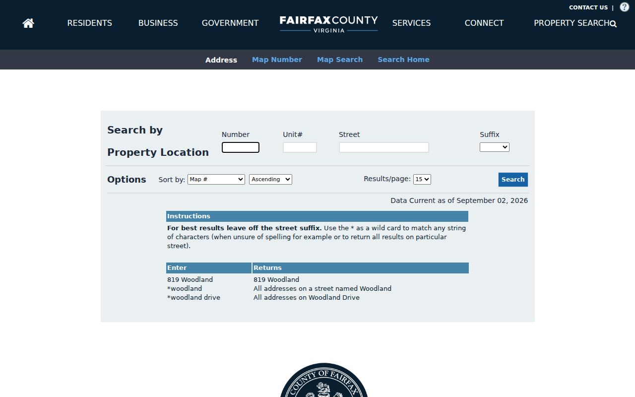
The distinct number, unit, street, and suffix controls make the search reproducible when a parcel result must be checked again.
Profiles can show Owners, Parcel Information, Legal Description, Sales, Values, Tax Information, and printable views. Ownership, characteristics, sale dates, and prices update twice weekly. Assessed values are as of January 1. The profile is not a boundary survey and it does not supply a recorded deed image.
Keep the returned tax-map or parcel identifier with the address terms. An iCare owner display can be withheld from the internet at an owner’s request, while the county still makes the information available through DTA’s office or phone channels as applicable. A blank web field therefore calls for a custodian check, not an assumption that the parcel has no recorded owner.
DTA’s public office is at 12000 Government Center Parkway, Suite 223, Fairfax, Virginia 22035, and its telephone number is 703-222-8234. Walk-in and phone service is listed Monday through Friday, 8 a.m. to 4:30 p.m. The county also identifies automated real-estate information at 703-222-6740, Monday through Saturday, 7 a.m. to 7 p.m.
Map Lorton Street Parcels in Jade
Jade supplies the geography that an assessment search lacks. Search by address with house number, street name, and type, or use a parcel PIN, street intersection, or subdivision when the number is unclear. Enable parcels and any needed layers, then click or rectangle-select lots. Map tips provide key attributes, while additional details expose full attributes and related links.
Jade’s groups include Property & Planning, Community, Infrastructure & Environment, Basemaps, and Imagery. After selecting parcels, use buffer options to inspect nearby features, switch to a table, zoom to all, or export CSV, XLSX, or a zipped shapefile where enabled. Historic imagery can provide address-continuity context. The map is evidence of mapped geometry, not a legal survey.
- Parcel
- A county-mapped piece of land identified by a tax-map number or PIN; it is the bridge between an address result and property records.
- Situs address
- The physical address associated with the parcel, which can differ from the tax-bill mailing destination.
- Plat
- A recorded map that can identify a subdivision, lot, block, or boundary reference. Use the recorded plat or deed for legal authority.
- Criss-cross directory
- A historical address-order directory, if an actual cataloged volume confirms that it includes one.
Note: A PIN, legal description, and subdivision name are stronger cross-checks than assuming consecutive street numbers are part of one tract.
Compare Lorton Street Directory Sources
A Lorton street directory uses several address-keyed systems. iCare is the current assessment layer. Jade and MAR resolve geography and address history. Court records explain transfers, and PLUS captures property-related public-record clues. The table keeps those roles separate, so a result is not asked to prove more than it can.
| Address source | What it can show | Access route |
|---|---|---|
| iCare assessment | Owner display, legal description, current values, sales, and mailing versus situs fields. | Free web search, DTA office, or phone; internet owner withholding may apply. |
| Jade GIS | Parcel geometry, layers, imagery, nearby features, reports, and exports. | Free county web map with selection and export tools. |
| MAR address system | Address status, historic or current record, PIN, ZIP, street, and subdivision. | Free Fairfax GIS search; it does not provide DTA owner data. |
| CPAN and HRC deeds | Deeds 1742-present, with CPAN data from 1980 and book 5391, plus earlier index-book images. | Research-room terminal or paid CPAN; HRC holds original deed books through 1942. |
| PLUS and LDIH | Permits, enforcement, planning, zoning, site, health, and fire clues. | Public PLUS search; use LDIH if an older item is absent. |
| Virginia Room directories | Potential historical address, telephone, school, and local-context evidence. | In-person catalog and shelf check; exact Lorton runs are not published. |
A sufficiently specific request can use the Virginia Freedom of Information Act, Va. Code §2.2-3704, but exemptions and protected information still apply.
Check Lorton Street Address History
Fairfax MAR is the county’s authoritative site-address route. It filters address number, street name and type, city, ZIP, parcel ID, subdivision, and created or expired date ranges. Current, historical, and all-status options help when a street number returns no match. Search by PIN when the number is uncertain, then compare the result with the parcel legal description.
Older Lorton material may be filed by tract, subdivision, road, or place name rather than a modern street label. Try Laurel Hill, Mason Neck, Occoquan, Lorton Station, Lorton Valley, Route 1, and the legal description alongside the street name. The former Laurel Hill site can also appear under Lorton prison, reformatory, workhouse, or related historic terms. No official source established a Lorton-wide renumbering year, so a failed modern-number search calls for broader terms, not a guessed date change.
Follow Lorton Street Deed Chains
Fairfax Circuit Court land-record research separates the deed image and index routes. Fairfax land records run from 1742 to the present. CPAN reports land-index data from 1980 forward, beginning with book 5391, and index-book images from 1742 through 1979, A1 through 5390. The Historic Records Center has original deed books from 1742 through 1942 and grantor/grantee index books for 1866 through 1946.
Start with the latest transfer attached to the iCare legal description. Record grantor, grantee, instrument number or book and page, recording date, and subdivision or tract wording. Then search the seller as an earlier grantee. Repeat backward, testing initials, marital names, estates, trusts, corporate parties, and legal descriptions. Early deeds may name a farm, road, creek, or adjacent owner instead of the current Lorton street number.
The Historic Records Center is at 4110 Chain Bridge Road, Suite 317, Fairfax, 703-246-4168, Monday through Friday 8 a.m. to 4 p.m.; an appointment is requested. CPAN is the paid remote route, while the Circuit Court Research Room offers public-terminal research. Retain the instrument number or book/page before seeking a copy.
Find Lorton Street Permit Clues
Fairfax PLUS searches Site Address or Parcel Number and exposes record number, record type, project name, date range, unit, city, state, ZIP, parcel ID, and additional criteria. It covers building, enforcement, environmental health, fire, planning, site, and zoning. Public browsing needs no login, while applications, payment, tracking, and notifications use an account.
PLUS replaced FIDO, PAWS, and ProjectDox beginning October 31, 2022. If an older result is missing, use the Land Development Information History system as the named fallback. A permit can date construction, an addition, a conversion, or a code matter. It does not establish a list of people at the address. Land Development Services lists permit support at 703-222-0801.
PLUS does not publish a complete inspected record-type list or an exact historical cutoff for every record category. Treat a no-result search as a reason to try another documented field, then use LDIH or the county support route. Do not turn a permit party, project name, or address into a claim that the person lived on that Lorton street.
Note: Search PLUS by parcel as well as address when a project uses a subdivision, lot, or legacy address format.
Keep Lorton Street Voter Searches Limited
The Virginia Citizen Portal is a person-specific tool, not a Lorton street roster. It requires first name, last name, date of birth, last four SSN digits, Fairfax County locality selection, and an affirmation that the record is the user’s or that the user has express authorization. The form warns that unauthorized access can be unlawful computer fraud.
Virginia Code §§24.2-405 and 24.2-444 control voter-list products and fields. The state request form is for statutory client types and filtered products, not a way to browse a street. Its field rules restrict sensitive identifiers and protected-address handling. Confirm an authorized individual record when appropriate, but do not expect an address search to reveal everyone registered nearby.
Use Lorton Street Directory History Carefully
The Virginia Room and the Fairfax local-history guide are public routes for city directories, telephone books, newspapers, property history, and yearbooks. A reverse or criss-cross directory, if a cataloged volume has one, arranges entries by address and can help place a historical household on a street. Exact Fairfax or Lorton years, publishers, and reverse runs were not published in the official material inspected.
Ask staff for a catalog and shelf check instead of assuming an unbroken run. Confirm printed year, publisher, abbreviation key, address section, and page before using an entry. The Lorton city directories collection keeps the historical shelf and household method separate from this current parcel trail.
Respect Lorton Street Directory Limits
A parcel owner is not necessarily every person at that address. Assessment records do not normally identify other occupants, guests, or people who occupy property without holding title. DMV address data is protected, utility customer lists were not located as a public source, and sealed court, vital, and adoption material stays controlled. Virginia’s Address Confidentiality Program and protective-address rules can also replace or shield a residential location.
A careful Lorton street directory check separates a physical situs, tax mailing destination, ownership record, and historical household clue. Each needs its own source and date. That restraint matters in a county record system where the postal community is not a separate municipality.